


Near Udaipur
Nathdwara (Shrinathji Temple) - 45 KM
Nathdwara is a significant Vaishnavite shrine pertaining to the Pushti Marg or the Vallabh Sampradaya or the Shuddha Advaita founded by Vallabha Acharya, revered mainly by the people of Gujarat and Rajasthan, among others. Vitthal Nathji, son of Vallabhacharya institutionalised the worship of Shrinathji at Nathdwara.
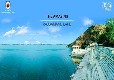
Rajsamand - 61 KM
Rajsamand is a city, located in Rajsamand district of Rajasthan, western India. The city is named for Rajsamand Lake, an artificial lake created in the 17th century by Rana Raj Singh of Mewar. It is the administrative headquarters of Rajsamand District.

Mount Abu - 163 KM
Mount Abu is a hill station in western India’s Rajasthan state, near the Gujarat border. Set on a high rocky plateau in the Aravalli Range and surrounded by forest, it offers a relatively cool climate and views over the arid plains below. In the center of town, Nakki Lake is a popular spot for boating. Close by are the centuries-old Dilwara Temples, ornately carved from white marble and of great spiritual importance. Distance from Udaipur : 163 km
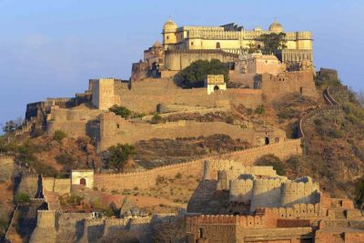
Kumbhalgarh - 84 KM
Kumbhalgarh is also known as the Great Wall of India, is a Mewar fortress on the westerly range of the Aravalli Hills, just about 48 km from Rajsamand city in the Rajsamand district of the Rajasthan state in western India. It is located about 84 km from Udaipur. It is a World Heritage Site included in Hill Forts of Rajasthan. It was built during the 15th century by Rana Kumbha. In 2013, at the 37th session of the World Heritage Committee held in Phnom Penh, Cambodia, Kumbhalgarh Fort, along with five other forts of Rajasthan, was declared a UNESCO World Heritage Site under the group Hill Forts of Rajasthan. Distance from Udaipur : 84 km
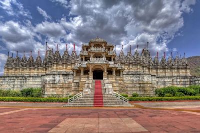
Ranakpur - 94 KM
Ranakpur is a village located in Desuri tehsil near Sadri town in the Pali district of Rajasthan in western India. It is located between Jodhpur and Udaipur. 162 km from Jodhpur and 91 km from Udaipur, in a valley on the western side of the Aravalli Range. Ranakpur is widely known for its marble Jain temple, said to be the most spectacular of the Jain temples. Distance from Udaipur : 91 km
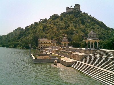
Jaisamand Lake - 58 KM
JAISAMAND LAKE: Jaisamand Lake, also known as Dhebar Lake, is a man-made lake situated in the Udaipur district of Rajasthan. It is India's second-largest artificial lake after Govind Ballabh Pant Sagar, and among the major places to visit as part of Udaipur tour packages. Maharana Jai Singh built Jaisamand Lake in 1685 AD while building a dam over the Gomati River. The statistics of the lake are 14 km in length, 9 km in width, and 102 feet in depth. The lake has a circumference of 30 miles. Distance from Udaipur : 58 km
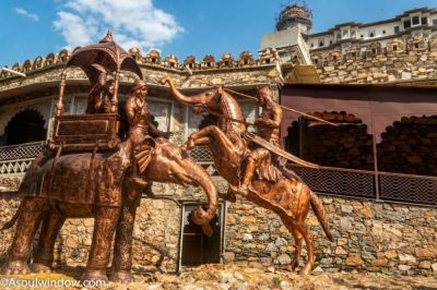
Haldighati - 44 KM
Haldighati is a historic mountain pass between Khamnore and Balicha village situated at the Aravalli Range of Rajasthan in western India which connects Rajsamand and Udaipur districts. Haldighati also known as Haldighati Darra.The pass is located at a distance of 44 kilometres from Udaipur. The name 'Haldighati' is believed to have originated from the turmeric-coloured yellow soil of the area.
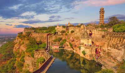
Chittorgarh - 110 KM
Chittorgarh is a major city in Rajasthan state of western India. It lies on the Berach River, a tributary of the Banas, and is the administrative headquarters of Chittorgarh District. It was a major stronghold of the Rajput State of Medapata. (Modern Mewar) The city of Chittorgarh is located on the banks of river Gambhiri and Berach. Chittorgarh is home to the Chittor Fort, the largest fort in India and Asia. It was sacked thrice; first in 1303 by Alauddin Khalji, again in 1535 by Bahadur Shah of Gujarat, and lastly by the Mughal Emperor Akbar in 1568. Its Hindu Rajput rulers fought fiercely to maintain their independence.